


Researchers are using artificial intelligence and advanced satellite radar to find thousands of years of human history buried under the sands of the Rub’ al Khali, one of the world's most forbidding deserts. This new approach to archaeology is revealing potential settlements and ancient trade routes without traditional, large-scale excavations.
The technology allows scientists to see beneath the massive dunes of the Arabian Peninsula, identifying structures and pathways that have been hidden for millennia. The findings, centered on sites in the United Arab Emirates, point to thriving Bronze Age communities that adapted to a much different climate than the one that exists today.
Key Takeaways
- Scientists are using Synthetic Aperture Radar (SAR) and AI to map archaeological sites in the Rub’ al Khali desert.
- The technology has identified potential human settlements dating back 5,000 years, particularly around the Saruq Al-Hadid site in Dubai.
- SAR can penetrate dry sand and soil, revealing features invisible to standard optical satellites.
- Machine learning algorithms are trained to recognize patterns of human activity, distinguishing them from natural geological formations.
- This method is helping researchers trace ancient trade networks, including the historical Incense Route.
A New Era of Digital Archaeology
The Rub’ al Khali, also known as the Empty Quarter, is the largest continuous sand desert in the world. Its extreme conditions, with summer temperatures often exceeding 120°F (48.89°C) and towering dunes, have historically made archaeological exploration difficult and dangerous.
Traditional methods relying on physical surveys and excavations are slow and often impractical across such a vast and inhospitable landscape. However, the combination of satellite imaging and artificial intelligence is changing how researchers explore these challenging environments.
Instead of relying solely on ground crews, scientists can now analyze immense areas from remote locations. This digital-first approach significantly speeds up the discovery process, allowing archaeologists to focus their physical efforts on sites that have a high probability of containing significant historical artifacts.
The Power of Looking Beneath the Surface
The key technology in this effort is Synthetic Aperture Radar (SAR). Unlike optical satellites that capture images of visible light, SAR sends radar pulses toward the Earth's surface and measures the signals that bounce back. This allows it to create detailed images regardless of weather or time of day.
Crucially, SAR signals can penetrate dry materials like sand and soil, revealing the texture and shape of what lies beneath. This capability is ideal for desert archaeology, where entire settlements can be buried under shifting dunes.
What is Synthetic Aperture Radar (SAR)?
SAR is a form of radar used to create two-dimensional images or three-dimensional reconstructions of objects, such as landscapes. It uses the motion of the radar antenna over a target region to provide finer spatial resolution than conventional beam-scanning radars. In archaeology, its ability to penetrate surfaces makes it invaluable for detecting buried structures, ancient riverbeds, and old roadways.
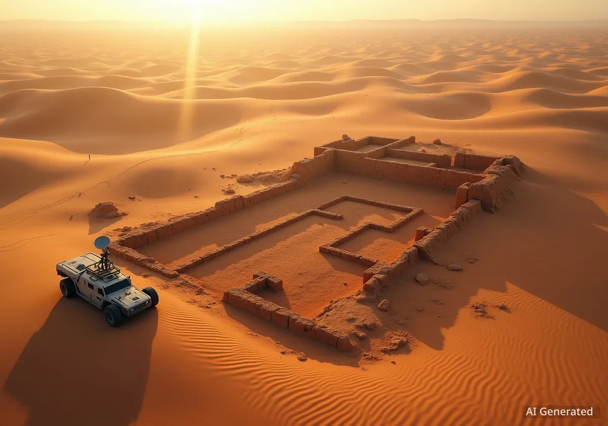
Focus on the Saruq Al-Hadid Site
A significant focus of this research has been the archaeological site of Saruq Al-Hadid, located near Dubai. First discovered in 2002, the site has yielded a wealth of Bronze Age artifacts, including metalwork, ceramics, and slag, which is a byproduct of smelting ore. These findings suggest it was a major center for metallurgy thousands of years ago.
Despite its importance, much of the Saruq Al-Hadid area remained unexplored, hidden beneath mobile dunes. A team of researchers from Khalifa University and Sorbonne University Abu Dhabi applied the new digital methods to map the region remotely.
Their work, published in the journal Geosciences, detailed how they used radar data from the ALOS-2/PALSAR-2 satellite combined with high-resolution optical images from the WorldView-3 satellite. This multi-layered data was then fed into a deep learning model.
Training the AI
The artificial intelligence was trained to identify patterns consistent with human settlements. Researchers fed it data from known archaeological sites, teaching it to recognize features like linear paths, dense clusters of materials, and subtle changes in ground composition that could indicate buried walls or foundations. The model achieved a resolution of up to 50 centimeters.
Verifying the Digital Discoveries
The predictions made by the AI were not just theoretical. When field teams were sent to verify some of the locations flagged by the algorithm, they found that many corresponded with buried features previously missed by conventional surveys. This ground-truthing process is essential for refining the AI's accuracy.
By confirming the model's predictions, researchers improve its ability to distinguish between man-made structures and natural formations that might look similar. Each verified discovery helps the algorithm become more precise, reducing the number of false positives in future scans.
"You’re not just finding isolated structures. You’re seeing corridors of human movement, economies, migration routes—entire civilizations that had adapted to live in the desert long before modern infrastructure." - Dr. Diana Francis, lead investigator.
Reconstructing Ancient Trade Networks
The project's scope extends far beyond the Saruq Al-Hadid site. Researchers are now applying the same techniques across the wider Arabian Peninsula to trace ancient trade routes that once crisscrossed the region.
These networks were vital for the movement of goods, ideas, and people, connecting inland oases with coastal settlements. One of the most famous of these was the Incense Route, a system of trade paths that transported valuable frankincense and myrrh from southern Arabia to markets in the Mediterranean and beyond, beginning as early as the 3rd millennium BC.
For a long time, the exact paths of these routes were largely hypothetical, pieced together from limited historical texts and a few known archaeological sites. The new satellite and AI analysis is making these invisible highways visible again, revealing how ancient peoples navigated and survived in what is now an extremely arid environment.
The Global Impact of AI in Archaeology
The use of AI to accelerate archaeological discovery is not limited to Arabia. Similar methods have proven successful elsewhere, demonstrating a global shift in the field.
- In 2023, researchers at Yamagata University in Japan used AI to identify new Nazca Lines in Peru, finding previously unknown geoglyphs 21 times faster than through manual analysis.
- In Mesoamerica, LiDAR (Light Detection and Ranging) technology combined with machine learning has uncovered vast Mayan cities hidden beneath dense jungle canopies.
What makes the Arabian project unique is the specific challenge of penetrating sand on such a massive scale. The success of SAR in this environment opens up new possibilities for exploring other large deserts around the world, such as the Sahara or the Gobi, which may also hold undiscovered histories.
Challenges and the Path Forward
While this technology is powerful, it is not without limitations. The accuracy of the AI models is highly dependent on the quality of the satellite data, which can be affected by atmospheric conditions like dust and wind.
Furthermore, the risk of false positives remains a challenge. Natural geological features can sometimes mimic the patterns of human settlements, requiring careful analysis and on-the-ground verification to confirm findings.
To overcome these issues, research teams are continuously refining their algorithms. They are using advanced neural networks with backpropagation, a method that allows the AI to learn from its mistakes. With every confirmed site and every identified false positive, the system becomes smarter and more reliable.
This pioneering work in the Rub’ al Khali is not just about finding old structures; it is about rewriting our understanding of human history in the region. It shows how ancient civilizations thrived in a changing climate and built complex societies in one of Earth's most challenging landscapes.